![Item #7564ba Chart of the Friendly Islands. [MAP]. Alexander Hogg](https://kurtgippert.cdn.bibliopolis.com/pictures/7564ba.jpg?width=320&height=427&fit=bounds&auto=webp&v=1522456039)
Chart of the Friendly Islands. [MAP]
London: Alexander Hogg, 1790. No Binding. Maps; South Pacific ocean; 8 3/4" x 13" engraved folded map; from Voyages by English explorer Captain James Cook 1728-79. More
London: Alexander Hogg, 1790. No Binding. Maps; South Pacific ocean; 8 3/4" x 13" engraved folded map; from Voyages by English explorer Captain James Cook 1728-79. More
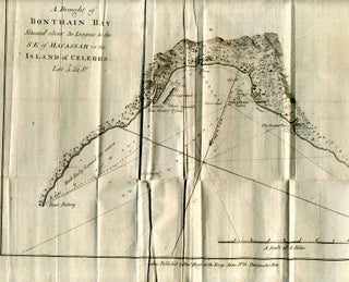
London: Alexander Hogg, 1790. No Binding. Maps; Netherlands Indies; 8" x 13" engraved folded map; from Voyages by English explorer Captain James Cook 1728-79. More

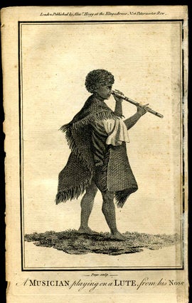
London: Alexander Hogg, 1790. No Binding. Americana; American Indians; Alaska; 4 images approximately 4 1/2" x 7 1/2"; man and woman on 1 sheet approximately 3 3/4" x 3 1/4" each; engravings from Voyages by English explorer Captain James Cook 1728-79. More
![Item #7578ba John Hawkesworth [portrait of] ... one of the editors of Cook's first voyage....](https://kurtgippert.cdn.bibliopolis.com/pictures/7578ba.jpg?width=320&height=427&fit=bounds&auto=webp&v=1522456039)
London: Alexander Hogg, 1790. No Binding. English history; exploration. 4 1/4" x 7 1/2"; engraving from Cook's Voyages. Engraving work by Alexander Hogg flourished 1778-1819. More
![Item #7556ba Map of Kerguelen's Land called by C. Cook Island of Desolation. [MAP]. Alexander Hogg](https://kurtgippert.cdn.bibliopolis.com/pictures/7556ba.jpg?width=320&height=427&fit=bounds&auto=webp&v=1522462178)
London: Alexander Hogg, 1790. No Binding. Maps; South Indian ocean; 9" x 10 1/2" engraved folded map; from Voyages by English explorer Captain James Cook 1728-79. More
London, UK: Alexander Hogg, 1790. First thus edition. Unbound. Octavo (8vo). Music; 4 1/4" x 7 1/2"; engraving from Cook's Voyages; South Pacific ocean. No date listed on engraving, but from a 1790 publication. Tiny spots of foxing present, and right edge is slightly stained from tape offsetting from reverse..... More
London: Alexander Hogg, 1790. Early edition. No Binding. An 8" x 13" engraved folded map published circa 1790. English explorer Captain James Cook 1728-79. Solomon Islands; South Pacific. More
![Item #7547ba Nova Hibernia. [MAP]. Alexander Hogg](https://kurtgippert.cdn.bibliopolis.com/pictures/7547ba.jpg?width=320&height=427&fit=bounds&auto=webp&v=1522456039)
London: Alexander Hogg, 1790. No Binding. Maps; 8" x 12 1/2" engraved folded map; 2" tear right side; profiles of prominent landfalls. More
![Item #7549ba Queen Charlotte's Islands. [MAP]. Alexander Hogg](https://kurtgippert.cdn.bibliopolis.com/pictures/7549ba.jpg?width=320&height=427&fit=bounds&auto=webp&v=1522456039)
London: Alexander Hogg, 1790. Early edition. No Binding. A circa 1790 engraved folded map, measuring 8 1/2" x 13 1/4". Originally issued in a book on the voyages by English explorer Captain James Cook (1728-79). Solomon Islands; South Pacific. More
![Item #7554ba Sketch of the harbour of Samganooda, on the Island Conalaska. [MAP]. Alexander Hogg](https://kurtgippert.cdn.bibliopolis.com/pictures/7554ba.jpg?width=320&height=427&fit=bounds&auto=webp&v=1522456039)
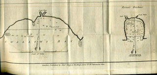
London: Alexander Hogg, 1790. No Binding. Maps; Aleutian islands; 8" x 13" engraved folded map; from Voyages by English explorer Captain James Cook 1728-79. More
![Item #7552ba Wanooaette Isl., Wateeoo Is.; Mangeea Island; Toobouai Island. [MAP]. Alexander Hogg](https://kurtgippert.cdn.bibliopolis.com/pictures/7552ba.jpg?width=320&height=427&fit=bounds&auto=webp&v=1522456039)
London: Alexander Hogg, 1790. No Binding. Maps; South Pacific ocean; Cook islands; 12 3/4" x 8" engraved folded map; 2 right margin tears; from Voyages by English explorer James Cook 1728-79. More