REPORT OF THE SUPERINTENDENT OF THE COAST SURVEY, Showing the Progress of the Survey during the Year 1855.
Washington: A. O. P. Nicholson, Printer, 1856. First Edition. Hardcover. Quarto (4to). Good+ condition. Item #016486
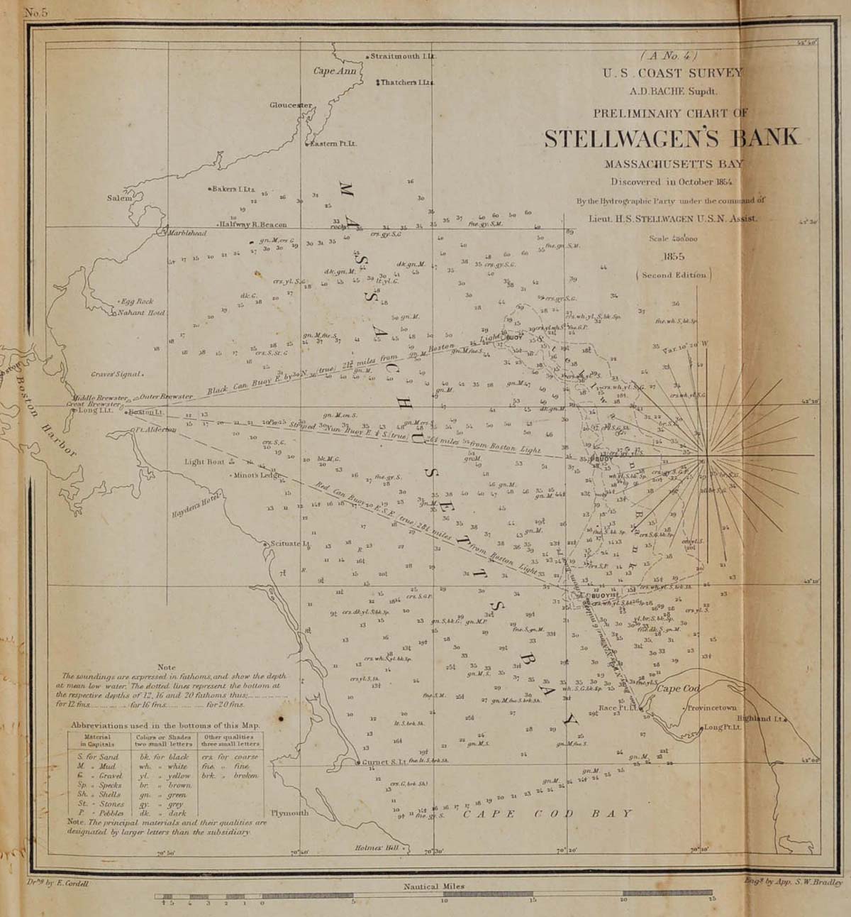
xx, 420 pages of text. Original brown cloth binding is quite worn, with half of the spine detached (but present) and chips missing, and the front board detached. Small label at the bottom of the spine. Theological seminary bookplates on the inside front cover, without any marking in the text. Very minor foxing to the text. Complete with 60 maps, most of which are fold-out, and many of which are large. Includes: 13 progress sketches; Portland Harbor; Ipswich and Annisquam Harbors; Stellwagen's Bank, entrance to Massachusetts Bay; Muskeget Channel; Hudson River; Sandy Hook changes; Seacoast of Virginia and entrance to Chesapeake Bay; Delaware and Chesapeake Bay; James River; Albemarle Sound; Cape Fear River; Gulf Stream explorations; Winyah Bay and Georgetown Harbor; Comparative Chart, Maffitt's Channel; Comparative Chart, Charleston Bar; Port Royal entrance; Savannah River; Romerly Marshes; Doby Bar and Inlet; Florida reefs (3); Legare Anchorage; Tampa Bay; Cedar Keys and approaches; Ocilla River; St. Andrews Bay; Biloxi Bay; Deep-sea soundings, Gulf of Mexico; Entrance to Vermilion Bay and Calcasieu River; Gavleston Bay; Progress sketch of Washington Sound and vicinity, Washington Territory; San Pedro anchorage and vicinity of Santa Barbara; South Farallon Island; Point Reyes and Drake's Bay; Alden's reconnaissance of Western Coast from Umpquah River to northern boundary; Co-tidal lines, Pacific Coast; Earthquake waves.-Pacific Coast; Boutelle's scaffold for stations, and Farley's Signal; Boutelle's apparatus for measuring preliminary bases; Sands' gas-pipe Tripod; Sands' specimen Sounding Box and Revolving Heliotrope; Lines of equal Magnetic Declination on the coast of the United States; Geological map, Point Reyes and vicinity; Geological map, vicinity of the Golden Gate; Geological map, vicinity of Monterey Bay; Geological map of the country between San Diego and the Colorado River. The maps are generally in very good condition, with some mis-folding, and several are torn (mostly at the folds), including one large tear into the image area, and another one that is browned at the exposed edge and a bit chipped, with overall minimal foxing. First edition.
Price: $650.00