![Item #8388bam Nebraska. [map]. George F. Cram](https://kurtgippert.cdn.bibliopolis.com/pictures/8388bam.jpg?width=320&height=427&fit=bounds&auto=webp&v=1421170428)
Nebraska. [map]
Chicago, IL: Henry S. Stebbins, 1886. Maps; matted; 12 1/2" x 9 1/2"; colored; from Cram's unrivalled family atlas of the world. More
Chicago, IL: Henry S. Stebbins, 1886. Maps; matted; 12 1/2" x 9 1/2"; colored; from Cram's unrivalled family atlas of the world. More
![Item #8386bam New Hampshire & Vermont. [map]. George F. Cram](https://kurtgippert.cdn.bibliopolis.com/images/noimage.png?auto=webp)
Chicago, IL: Henry S. Stebbins, 1886. Maps; matted; 9 1/2" x 10 3/4"; colored; from Cram's unrivalled family atlas of the world. More
Chicago: George F. Cram, 1878. Early edition. Hardcover. 24mo - over 5" - 5¾" tall. Beautiful folding map of Missouri, printed in 1878, a reprinting the 1872 impression. Original brown protective case with minimal shelfwear, remaining quite clean and bright. The interior Census paste-down page is clean and bright; minor..... More
Chicago, IL: Henry S. Stebbins, 1886. No Binding. Maps; matted; 18" x 12"; North America; colored; from Cram's unrivaled family atlas of the world. More
Chicago, IL: Henry S. Stebbins, 1886. Maps; Australia; New Zealand; New Guinea; Borneo; Polynesia, et al; 11 3/4" x 9 1/4"; colored; from Cram's unrivalled family atlas of the world. More
Chicago, IL: Henry S. Stebbins, 1886. Maps; matted; 18" x 12"; Pennsylvania; colored; from Cram's unrivaled family atlas of the world. More
Chicago, IL: Henry S. Stebbins, 1886. No Binding. Maps; matted; 18" x 12"; South America; inset of Isthmus of Panama; colored; from Cram's unrivaled family atlas of the world. More
Chicago, IL: Henry S. Stebbins, 1886. Maps; matted; 12" x 9 3/4"; colored; from Cram's unrivalled family atlas of the world. More
Chicago, IL: Henry S. Stebbins, 1886. Maps; matted; 11 3/4" x 9 1/4"; colored; from Cram's unrivalled family atlas of the world. More
Chicago, IL: Henry S. Stebbins, 1886. Maps; matted; 8 3/4" x 11 1/4"; colored; from Cram's unrivalled family atlas of the world. More
Chicago, IL: The University of Chicago Press, 1974. First Edition. Hardcover. Oblong octavo (8vo). 114 pages of text including an index. Illustrated with 34 facsimiles of Colonial maps. Mustard hardcover cloth binding. Price-clipped decorative dustjacket with brown and red lettering, with minor rubbing to extremities; protected in archival mylar. Published..... More
Paris: Esnauts et Rapilly, 1792. First thus edition. No Binding. Large antique fold-out map of Paris. Measures 31.5 x 21.5 inches, in 23 of 24 sections. Lacks the lower left corner section. Linen backed. Outline hand-color folding map. Inset overview of Paris, and tables at right and left margins. More
![Item #6173bg OHIO [folding pocket map]. Anthony Finley](https://kurtgippert.cdn.bibliopolis.com/pictures/6173bg_1.jpg?width=320&height=427&fit=bounds&auto=webp&v=1477439823)
Philadelphia, PA: Anthony Finley, 1830. Reissue. Hardcover. Miniature. 3-1/2" (height) x 2-1/8" (wide) original tan leather binding with gilt lettering "OHIO" on front cover, and decorative blind-tooled border. Contains an 11" x 8-1/2" hand-colored fold-out map with loss of one section at lower right corner (1" x 2-1/2") resulting in..... More
![Item #7564ba Chart of the Friendly Islands. [MAP]. Alexander Hogg](https://kurtgippert.cdn.bibliopolis.com/pictures/7564ba.jpg?width=320&height=427&fit=bounds&auto=webp&v=1522456039)
London: Alexander Hogg, 1790. No Binding. Maps; South Pacific ocean; 8 3/4" x 13" engraved folded map; from Voyages by English explorer Captain James Cook 1728-79. More
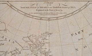
London: Alexander Hogg, 1790. No Binding. Maps; matted; 8 1/4" x 13"; folding visible; showing from above 70 degrees north longitude to below 50 degrees north longitude; Alaska noted. Alexander Hogg flourished 1778-1819. More
![Item #7562ba Christmas Island.[MAP] Discovered in the ships Resolution and Discovery. Alexander Hogg](https://kurtgippert.cdn.bibliopolis.com/pictures/7562ba.jpg?width=320&height=427&fit=bounds&auto=webp&v=1522456039)
London: Alexander Hogg, 1790. No Binding. Maps; South Pacific ocean; 8 1/2" x 11 3/4" engraved folded map; from Voyages by English explorer Captain James Cook 1728-79. More
London: Alexander Hogg, 1790. No Binding. Maps; Netherlands Indies; 8" x 13" engraved folded map; from Voyages by English explorer Captain James Cook 1728-79. More
![Item #7556ba Map of Kerguelen's land called by C. Cook Island of Desolation. [MAP]. Alexander Hogg](https://kurtgippert.cdn.bibliopolis.com/pictures/7556ba.jpg?width=320&height=427&fit=bounds&auto=webp&v=1522462178)
London: Alexander Hogg, 1790. No Binding. Maps; South Indian ocean; 9" x 10 1/2" engraved folded map; from Voyages by English explorer Captain James Cook 1728-79. More
London: Alexander Hogg, 1790. Early edition. No Binding. An 8" x 13" engraved folded map published circa 1790. English explorer Captain James Cook 1728-79. Solomon Islands; South Pacific. More
![Item #7547ba Nova Hibernia. [MAP]. Alexander Hogg](https://kurtgippert.cdn.bibliopolis.com/pictures/7547ba.jpg?width=320&height=427&fit=bounds&auto=webp&v=1522456039)
London: Alexander Hogg, 1790. No Binding. Maps; 8" x 12 1/2" engraved folded map; 2" tear right side; profiles of prominent landfalls. More
![Item #7549ba Queen Charlotte's Islands. [MAP]. Alexander Hogg](https://kurtgippert.cdn.bibliopolis.com/pictures/7549ba.jpg?width=320&height=427&fit=bounds&auto=webp&v=1522456039)
London: Alexander Hogg, 1790. Early edition. No Binding. A circa 1790 engraved folded map, measuring 8 1/2" x 13 1/4". Originally issued in a book on the voyages by English explorer Captain James Cook (1728-79). Solomon Islands; South Pacific. More
![Item #7554ba Sketch of the harbour of Samganooda, on the Island Conalaska. [MAP]. Alexander Hogg](https://kurtgippert.cdn.bibliopolis.com/pictures/7554ba.jpg?width=320&height=427&fit=bounds&auto=webp&v=1522456039)
London: Alexander Hogg, 1790. No Binding. Maps; Aleutian islands; 8" x 13" engraved folded map; from Voyages by English explorer Captain James Cook 1728-79. More
![Item #7552ba Wanooaette Isl., Wateeoo Is.; Mangeea Island; Toobouai Island. [MAP]. Alexander Hogg](https://kurtgippert.cdn.bibliopolis.com/pictures/7552ba.jpg?width=320&height=427&fit=bounds&auto=webp&v=1522456039)
London: Alexander Hogg, 1790. No Binding. Maps; South Pacific ocean; Cook islands; 12 3/4" x 8" engraved folded map; 2 right margin tears; from Voyages by English explorer James Cook 1728-79. More
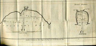
Nurenberg: Homann Heirs, 1740. First Edition. Unbound. Large map with original hand-coloring. Measures 22.5 (width) x 20.25 (height) inches. One part only of a set of 2 maps. This one shows the eastern part of Serbia, Walachia, and part of Bulgaria. It contains 7 inset maps of Widden, Nicopol, Nissa..... More