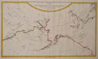
Karte von den N.W. Amerikanischen und N.Oe. Asiatischen Kusten, nach den Untersuchungen des Kapit: Cook in den Jah: 1778 und 1779. entworfen von Heinrich Roberts Lieut. [map]
Vienna, Austria: F. A. Schraembl, 1788. First Edition. Unbound. Folio. A large map, beautifully decorated with original outline color and a yellow and red border. The NW Coast of North America is shown from below the 50th parallel and north to above 70 degrees latitude. The NW corner of Hudson's..... More